Panpatia Col had been on my bucket list ever since I’d read about Shipton and Tilman’s fabled attempt to connect Badrinath and Kedarnath, spurred on by the lore of a priest who could offer venerations to the deities at both the shrines in a single day… ours would be just a segment of that epic traverse, sans the audacity or the technical wherewithal of the intrepid explorers of the yore, or the ones who followed in their footsteps… yet even a sliver of these desolate expanses is gold dust for those who keep daydreaming about them in their shrieking, sultry abodes…
When reading about the dependence of agriculture on the ‘vagaries of monsoons’ in geography textbooks, I’d never imagined that these winds – albeit compelled by the anthropogenic fallacy that is climate change – would make it a habit of pouring water over my trekking plans… but the last few years they’d been persistently foiling them, so much so that I’d switched allegiances from my preferred hiking time of the post-monsoon period to pre-, yet the clouds refused to dissipate… the monsoons were arriving early, dust storms and thunder showers were pummelling the lower plains, and the mountains were prepping up with their own concoctions of precipitation…
Navigating through such meteorological uncertainties, a drizzly Sunday morning found us at a metal bridge connecting the road at Hanuman Chatti to the trail winding its way up the Khiron Ganga valley… believing that whatever is wet today will be dry tomorrow, we tottered up to a gloomy sky, helicopters to Badrinath burping in the sky every fifteen minutes or so…
After walking along the riverbed for about half a kilometre, the trail started climbing up, and a gentle two and a half hour walk led us to Khiron village, a smaller settlement than I’d expected, the houses mostly locked… we camped about a kilometre further ahead, crossing a snow bridge over the river to a row of fields between the village and its head temple, a traditional stone construction embellished with modernity in parts…
The drizzle picked up as the tents were pitched around two in the afternoon, writing the prologue for the days ahead, where we’d end up spending a substantial amount of time mulling over the weather, and life in general, inside our humble contraptions of synthetic fabrics and aluminium… a tall and slim waterfall slithered down the mountain on the opposite side… narrow, dark, brooding gorges to begin with…
I finally had some time to go chase birds as the rain finally receded at five, allowing a couple of hours of stealthy and partly futile strolls behind a restive avifauna… we also spotted a large herd of blue sheep on the slopes above the waterfall… the village priest had come up in the meanwhile, raising a ruckus about our audacity to camp on his land, eventually blowing off all the steam and departing on a preachy note to be more careful in the future… Nanda Devi gave a brief glimpse before dusk took over and we settled in for the night…
A bright and clear morning emerged on the other side… and we started the day at eight-thirty with a steep climb along a ridge that bisected the mountain into two for a kilometre or so before a cairn style Durga temple marked the end of the treeline and we followed the spur of the mountain to our left, onwards to the meadows…
The gorge was still quite narrow than I’d expected, and there were a lot of snow bridges over the river, I’d never been this early into the trek … we crossed a couple of shepherd encampments, finding one herder resting beneath his blue tarp who needed little encouragement to strike up a conversation, beginning with the weather, as is the norm, and gradually gravitating towards the ways of the world and the contentment that came with earning an honest bread in the outdoors…
Cloudy skies greeted us as we reached the campsite at three, near the upper reaches of Khiron Nala, a rivulet that was merging into the larger river emanating from the Parvati glacier to form the Khiron Ganga… the sky was overcast now, a slight drizzle came and went… a couple of locals were also camped nearby, most probably looking for caterpillar fungus given that we couldn’t see any livestock… a slight throbbing in the back of the head reiterated a decent elevation gain for the day… surprisingly there weren’t many birds near the water, just a couple of white-capped redstarts calling out excitedly… mist started to fill the gorge as the sun receded, twilight draped in an ethereal cloak…
The weather was following the quintessential mountain pattern – clear mornings followed by a gradual buildup of clouds through the day… thankfully the precipitation was under control during these initial days… we started around eight the next day, the mist clinging to the river in the early dawn but then dissipating as the sun came up… about half an hour into the walk, we left the meadows and came the moraines, the valley finally opening up as we once came alongside the river after leaving its bank on the first day…
Reaching the next camp a couple of hundred metres below the snout of the Parvati glacier rather early at half past eleven, the landscape felt like the warmup was over, moraines and boulder fields surrounding our patch of flat ground… the afternoon sun was harsh, and being a member of the avoid-sunscreen-till-you-can’t club, one could feel the skin bracing itself for the annual high-altitude moulting…
Parvati river was frothing and fuming now, having just broken away from the glacier, hurtling down to be subsumed into the Alaknanda… there wasn’t much success in birding despite the frequent chirps ringing through the valley, probably because we were there early, there wasn’t much flowering, and it looked like the mating season hadn’t began as well… Nilkantha Col and Balakun peak were visible in the background as and when the clouds allowed a peep through… small rocks kept tumbling down the ice on the other side of the river, whose acoustics dominated the auditory canvas now…
A Tickell’s leaf warbler and a pipit showed some courtesy as the clouds drifted away towards the desolation of mountaintops… mist engulfed the valley as retired for the night… the glacier’s predisposed sigh at dusk I mused… but otherwise, another night in relative comfort and safety… the itinerary was moving rather slow to my usual fare, both in terms of the time spent hiking and the distances covered, but I was interested in seeing if it’d lead to better acclimatization… the inference turned out to be that I couldn’t really tell the difference in the end…
It started to drizzle around midnight and persisted awhile… luckily though, another clear sky greeted us at the six in the morning, duly followed by a procession of puffy clouds drifting in from the high peripheries, which were gleaming with the fresh snow dumped upon them overnight… an icefall off Balakun was the highlight of the scenery around us… sunlight seeped into the valley around seven, warming my toes that’d gone numb with another mostly futile attempt at stalking the early bird out to get the worm…
Six, seven, eight… wakeup, breakfast and move was our regular schedule, and cold nights meant that we were hitting the sack early to keep to it… porter squabbles upon loads was a recurrent theme, a universal feature of any expedition over the years, expert or novice, a constant amidst the flux that is mountain exploration… we had a disproportionately large entourage for just three people – three guides, a cook and ten porters, seemed extravagant but one really didn’t really mind the oversufficiency… a few stones shot down the slopes behind the camp as we were getting ready for, none too dangerous though…
Half a kilometre of meadows and then the moraines and boulder fields started well and proper… one rock shot down dangerously close to me and a guide but veered off our course well in time… with the sun up, the glacier was starting to croak and groan… we spent a few minutes watching the stream gushing out of the snout of the glacier… rocks sliding down upon it constantly, some splashing into the water, some getting an unfortunate bounce and veering off the course to settle along its bank… ‘twas a mesmerizing sight, perhaps one of the few where one can see and feel the glacier move, for otherwise this expanse of white and black and brown is a master of deception… its mobility veiled by an all-encompassing sense of stasis…
The trail was technical now… we slowly weaved our way up the glacier, alternating between rocks and ice… the overnight rain had made the mud soggy, and it kept slipping and sliding constantly, the rocks jittery and unstable… this was perhaps the first time I was walking over a glacier that had a large volume of hard ice, for post-monsoon, when I usually go, it is more mud and rock…
We crossed one prominent glacial lake, fed by a stream hurtling down a steep face, and several large puddles formed by the melting ice… at times one could hear the underground water channels scurrying down to coalesce into the river, but otherwise there was that typical pall of an eerie silence that characterizes a glacier, where the inanimate begins to feel alive…
Snow-clad peaks brooded over this melange of stone and ice, most of them unnamed, which seemed unfair, but it also highlighted the limited footfall this area has seen… the trail kept climbing steadily, there was just one small steep patch followed by a precarious downhill that was a bit challenging, rest was quite manageable… we reached the campsite around two-thirty in the afternoon, a small patch of flat land where the ice had melted… the clouds were moving in like them meant business, but were accommodating enough to allow us to settle ours first…
An icefall dropping off Panpatia snowfield came into view, the destination in sight now… the weather started turning as soon as we pitched camps, and at around four-thirty a storm came calling… heavy winds, rain, thunder and lightning… the full monty, I thought, laying inside the tent… by now we were well accustomed to this four seasons in a day trope, and largely unruffled by it…
‘Twas an hour and a half of a somewhat restrained fury… the weather giving us a glimpse of what it was capable of but never pushing the envelope… feeling like the clouds were quietly descending down the valley when the glacier decided to rob them at gunpoint to fill its underground coffers… we were now privy to the inner workings of the glaciers, and would try to keep hanging to their coattails for the next few days…
The night was uneventful, and we, with a sense of inevitability, woke up to clouds beginning to dawdle over blue skies… starting around eight thirty, the trail picked up from where we’d left off yesterday… choosing the path of least resistance meant sections of ice sufficiently covered with mud and rocks for friction, which sometimes led us to the centre of the glacier, and sometimes to the slopes, though the rain last evening meant more soft mud…
Moving at a fair clip despite the shaky terra firma, we arrived at a small icefield in a couple of hours that emanated from the icefall of Panpatia, the ten o’ clock ice starting to melt and trickle down into a glacial stream that disappeared into the depths of the glacier after a brief appearance… making a quick work of this patch, we veered off the icefall back into the moraines, climbing towards the base of Parvati peak, where the weather turned from bright sunshine to snowfall in a matter of five minutes, as I hurriedly chewed an apple… crossing a stream, we climbed up a ridge leading to the base of the Parvati gully, leaving the moraines for the domains of snow and ice…
Reaching the camp around noon, everyone got down to clearing the snow to make tent platforms… apart from the rigmarole of mandatorily trudging thorugh snow to get anywhere, the site was nice, overlooking the dark and imposing pyramidal massif of Parvati peak… it stopped snowing soon after we pitched the tents and the usual fare of clouds coming and going returned… from a distance, the moraines looked innocent once more… monsoons would soon drape them in white, but for now, the glacier seemed at ease, yawning while spawning…
Calling it an early night after dinner, we were woken up by a shouting porter at around ten thirty… unable to comprehend if the message was directed at us initially, the prompt to ‘clear the tent’ woke us up and made us realize that our tent was covered in snow… it’d been snowing for the past couple of hours, so softly that it didn’t make a sound but quietly kept accumulating on top of our canopy… the platform was on a slope so there was a possibility of the snow pushing the tent down…
Unzipping the tent rather dejectedly, we started to mull over the next course of action… to sleep or not to sleep, that was the question… the weather wasn’t bad enough to go on survival mode and stay awake the whole night, so I put an alarm for every hour to clear the snow, and we stuck to it diligently… at around two thirty in the early morning the snow finally relented and we could finally catch a few hours of uninterrupted sleep…
As the morning light filtered in, we took stock of the situation, around six inches of snow had fallen during the night… the gleaming white a treat to look at but a chore to wade through… the sky was still overcast but the threat of precipitation looked slim… with everything wet and cold, it took more time to break camp, and we could only start around nine… one of the porters didn’t bring sunglasses so I had to sacrifice my clip-ons, burning two holes on its side and putting a thread to tie it around the head…
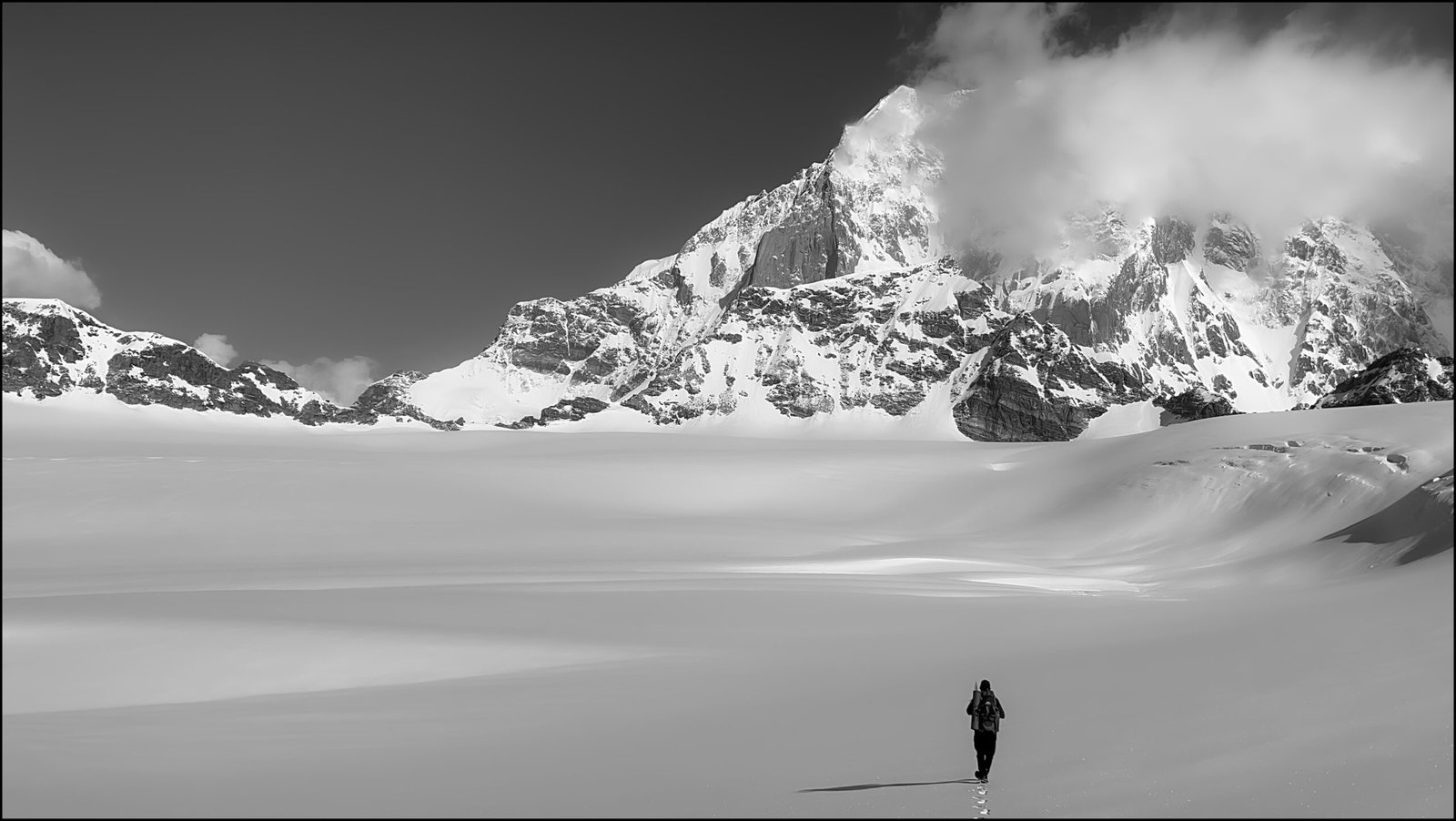
In Test cricket parlance, today was the ‘moving day’, when we’d climb out of the valleys of Badrinath start entering those of Kedarnath… climbing steeply though snow topped boulders, we soon came to a tricky patch of wet rocks that demanded all four limbs, perhaps the most precarious section of the entire trail… thankfully it wasn’t long, and about an hour and a half’s trudge from the camp found us at Parvati Col, staring at snowfields proper now, a seemingly endless expanse of white… the mist conjuring up a slow lilt of light and shadow in an otherwise monochrome landscape…
‘Twas here that the guide pointed that Panpatia Col is actually two passes, a col ‘up’ that leads into the snowfield, and a col ‘down’ for exit, none of the itineraries I’d read mentioned this, something that I found rather intriguing, although a map on this page does mark a Panpatia I and II… interestingly, the GPS showed both to be at exactly the same height…
We continued to climb after Parvati Col, the snow conditions were decent but the altitude was making itself felt now… an hour of crawling up brought us to the col ‘up’… banners were unfurled and profile photos were shot aplenty… it’d taken us five days and kaleidoscopic terrains to reduce the landscape to just the purest shades of white… I preferred to wait for the crux of the descent to pass though before deeming the footslog a success…
The icefield flattened as we crossed the col, mist all around blocking the promised panoramic views of the Himalayan giants… a half hour plod in the snow delivered us to the campsite around one thirty, a flat patch of land just above a field of crevasses, at an elevation higher than the col… exposure was the selection criteria now instead of water availability… once again the weather held up just long enough as we pitched camp and then it started to snow…
Holed up inside the tent, we tried to warm ourselves in vain… I usually open the sleeping bag only once I’m ready to go to sleep to avoid succumbing too early to its warm comforts, but with the ice cold floor seeping into the bones, this wasn’t an option… out came also the rest of the paraphernalia including warm pants, gloves and fleece liners… the snow while persistent wasn’t as heavy as the night before, but strong enough to discourage any excursions outside…
Another early dinner and we folded up, the snowfall had subsided but was replaced with biting winds and a whiteout… waking up in the night to answer nature’s call after much internal dialogue, I was treated to a starry sky, the familiar strip of the Milky Way glistening with its celestial wares…
There was that familiar white-out as we re-opened the tent flap at dawn, but it cleared up in five minutes, and we were finally regaled with a full view of Chaukhamba, its imposing massif feeling like a stone’s throw away… despite the lack of the sun’s warmth, everyone just stood mesmerized at this gargantuan sight, evoking a mixture of appreciation and apprehension…
I walked away to the other side to see what the horizon there had to offer, and the familiar silhouettes of Nanda Devi, Dunagiri and Hathi Parvat emerged briefly before being swallowed up by the clouds… this view would best characterize the trail, one felt… seeing a prominent peak up and close feels akin to seeing someone in flesh and blood…
We’d planned to start a bit earlier at seven, but with every movement cold and laboured before the sun reached us, ‘twas seven thirty by the time we got moving… the shortest route being riddled with crevasses, we took to plodding along the circumference of the glacier… a couple of loud booms under the feet startled us, consensus being that these were air bubbles bursting… they got us moving faster though…
From the camp, the end of the icefield felt like a couple of miles away, turned out that ‘twas almost double the distance at around six kilometres… the clock read ten thirty as we reached the cairn temple from where we’d begin the descent… with the sun shining bright and very little wind, it was a tiring trod, glacier lassitude maybe, one thought… but we were safe from any hidden entrapments now… looking back, we could see the top of the icefall that had greeted us from the base of the Parvati glacier…
A steep rock section followed by snow awaited us on the other end… we waited for about half an hour for the porters to catch up, but they were being slowed down by their loads in the melting snow, so the puja was performed in the meanwhile, incenses and offerings of copra…
The initial part of the descent was steep, the rock section turned out be shorter and less challenging than it looked from above… the snow was quite amenable to cutting steps too… clouds filled the valley and it started to snow around noon… but we were much relaxed now and making good speed on the descent… this was Chaukhamba’s domain, the mountain whipping up clouds like cotton candy… after descending a couple of kilometres, crossing a frozen lake, we started climbing up… an upside of overcast conditions was the perfect snow conditions for walking, we hardly ever sank beyond the knee…
Around two o’ clock we reached the frozen fields that embosomed Sujal Sarovar, a small glacial lake with emerald green waters, offering another angle of Chaukhamba… yet again it started snowing just after we pitched camp… by now we seriously doubted if this was serendipity and pondered over the possibility of some divine design, one that had been in our favour thus far…
Once we’d entered the glacial realms, there hadn’t been a single evening where the weather permitted evening – and in most cases even morning – excursions, and today was no different… I surmised that this would be the leitmotif of most high-altitude outings pre-monsoon, as the mountains prepared for a spike in hydrological activities… but as long as we were able to avoid getting wet while hiking, the disappointment of not being able to observe the landscapes during the golden hour could be overlooked…
The snowfall persisted, and next morning we had another six-seven inches or overnight activity to clear out… as the sun came up, one could hear avalanches going off on Chaukhamba, and we saw a big one roll down the mountain… far away from these dangers now, we could look at them with awe rather than trepidation…
A short climb of a couple of hundred metres though soft snow brought us to the pass above Sujal Sarovar, from where we would start descending towards the Madmaheshwar valley… for a while one couldn’t tell if the snow was making the boulder strewn trail easier or trickier to navigate, but we could see green meadows and the treeline in the distance, Madmaheshwar Ganga cutting its way through the bottom, a welcoming sight that buoyed the spirits… many sub-five thousand metre passes dot this landscape, offering interesting routes and permutations, including the meadows of Pandusera and the Ghia Vinayak pass…
Half an hour of snow and boulders bought us to the frozen Maindha Tal, from where the snow more or less dissipated, and the trail alternated between boulder patches and grass, the going a tad slow but steady, and despite the fact that I took more fall and slips on this two kilometre stretch than the entire trek, the trail felt easier… we reached the campsite at Kachni Khal around twelve thirty as a drizzle began, camping right on top of the pass overlooking Madhmeshwar temple and the town of Guptkashi further down the valley, next to Kachni Dhar originating from Kachni Tal a couple of miles higher up…
By now the phenomenon of the weather turning after the tents were pitched was more a predisposition than perchance, but we were a little bit taken by surprise at the intensity of the hailstorm that followed… as if the mountains, miffed at not being able to summon snow, pelted down the next best alternative instead… my father’s in the ice business, my tent mate remarked rather drily, and one couldn’t help but titter, for who knows a chortle might deride the weather gods even further…
We looked at the carpet of green metamorphose into white with a feeling of bemusement, our tryst with whimsical precipitations not over yet… around five in the evening, as we were sipping tea and coffee in the kitchen tent, a strong wind threatened to uproot our unoccupied tent, so much so that us two occupants had to rush inside to prevent it from happening… we’d probably have been more concerned at such weather before, but there was an overarching sense of comfort now as we neared civilization… there was Jio cell phone network but no Airtel, as is the case in many remote parts of the state these days… only voice connectivity though, no data…
The weather cleared around five in the evening, and I had a stroke of luck as I went out looking for pikas and managed to spot two, one of them acquiescing to be photographed… making a mental note to exit the tent carefully at night as ours was pitched right at the edge of the slope, I called it an early night, going from shivering inside the sleeping bag to sweating now…
From hereon there was a trail maintained by the forest department, and we hopped on to it at eight thirty the next morning, the descent punctuated with yellows and reds and purples as there were more flowers on this side as compared to Khiron valley… saw a couple of camera traps on the way down, and some metal debris purported to have fallen from crashed helicopters…
Two and a half hours and five kilometres later, we found ourselves at Madmaheshwar temple, surrounded by a few guest houses and a steady trickle of pilgrims, offering a quick prayer, we continued descending, on to a wide mule trail now, inviting at first but getting irksome pretty fast as the knees took a pounding… chips, soft drinks, Bluetooth speaker and selfie sticks, one wondered if this would take more acclimatizing vis-à-vis the altitude…
Another five kilometres found us at an open patch of land at Nanu Chatti, our campsite for the day, surrounded by the familiar oak and rhododendron forests… Kachni Khal was visible at a distance, the clouds dishing out their regular fare there… this was the beginning of the end… cell phone reception was back, and spirits were high…
We were up at four thirty the next morning, eager to get going, for the past ten days our mobility was in our hands, but with the end of the trail, the unpredictability of roads and traffic would return… the mule trail continued descending till Gaundhar and then climbed back up to Ransi… unlike last year, where I had a terrible time negotiating the hordes of people and mules at Yamunotri, the trail wasn’t crowded… the pines made a return as we reached the road, where we waited for about an hour for the taxis… the porters moving back to Joshimath, most of them would return to this very trail again in the coming week, while the rest of us continued downhill, where the sultriness and mosquitoes lay in wait…


Itinerary
Note: Distances were recorded through a GPS-enabled watch, but some days I felt that they was grossly under recorded, especially when the terrain had a lot of vertical distances to cover (probably because this model does not have a 3D distance mapping feature), and also when the conditions were overcast in the higher reaches. For such days, both the recorded and perceived distances are listed.
Day 1: Drive from Joshimath (1,875) metres to Hanuman Chatti (2,410 metres): 30 kms, 1 hour; hike from Hanuman Chatti to campsite above Khiron village (2,800 metres): 3.7 kilometres, 2.5 hours
Day 2: Campsite above Khiron village (2,800 metres) – Shepherd Camp/ Nala Camp/ Khiron Nala Camp (3,600 metres): 4.2 kilometres, 4 hours (felt like 6 kilometres at least)
Day 3: Shepherd Camp (3,600 metres) – Snout Camp (3,800 metres): 3.3 kilometres, 3 hours
Day 4: Snout Camp (3,800 metres) – Moraine Camp (4,300 metres): 4.5 kilometres, 5.5 hours
Day 5: Moraine Camp (4,300 metres) – Parvati Gully Base Camp (4,750 metres): 3.5 kilometres, 4 hours (felt like 6 kilometres at least)
Day 6: Parvati Gully Base Camp (4,750 metres) – Parvati Col (5,000 metres) – Panpatia Col ‘Up’ (5,230 metres) – Panpatia Icefield Camp (5,260 metres): 3 kilometres, 4 hours (felt like 5-6 kilometres at least)
Day 7: Panpatia Icefield Camp (5,260 metres) – Panpatia Col ‘Down’ (5,230 metres) – Sujal Sarovar (4,640 metres): 10 kilometres, 6.5 hours
Day 8: Sujal Sarovar (4,640 metres) – Kachni Khal (4,230 metres): 3 kilometres, 3.5 hours (felt like 5-6 kilometres at least)
Day 9: Kachni Khal (4,230 metres) – Madmaheshwar Temple (3,500 metres) – Nanu Chatti (2,360 metres): 10.65 kilometres, 4.5 hours
Day 10: Nanu Chatti (2,360 metres) – Gaundhar (1,600 metres) – Ransi (1,900 metres): 10 kilometres, 4 hours
Every time you post, your stories make me gasp in awe of the beauty that mountains behold!
Such lovely writing. I think I would have understood the trek even if I was not there with you.